


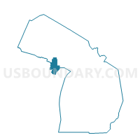
Voting District 1095302000002, Menominee County, Michigan
About
Outline

Summary
| Unique Area Identifier | 598263 |
| Name | Voting District 1095302000002 |
| County | Menominee County |
| State | Michigan |
| Area (square miles) | 1.44 |
| Land Area (square miles) | 1.24 |
| Water Area (square miles) | 0.20 |
| % of Land Area | 86.04 |
| % of Water Area | 13.96 |
| Latitude of the Internal Point | 45.11044980 |
| Longtitude of the Internal Point | -87.63877300 |
Maps


Graphs
Select a template below for downloading or customizing gragh for Voting District 1095302000002, Menominee County, Michigan


Neighbors
Neighoring Voting District (by Name) Neighboring Voting District on the Map
- Voting District 1095302000001, Menominee County, MI
- Voting District 1095302000003, Menominee County, MI
- Voting District 1095304000001, Menominee County, MI
- Marinette - C 6 Voting District, Marinette County, WI
- Marinette - C 8 Voting District, Marinette County, WI
- PORTERFIELD - T 2 Voting District, Marinette County, WI
Top 10 Neighboring County Subdivision (by Population) Neighboring County Subdivision on the Map
- Marinette city, Marinette County, WI (10,968)
- Menominee city, Menominee County, MI (8,599)
- Menominee township, Menominee County, MI (3,488)
- Porterfield town, Marinette County, WI (1,971)
Top 10 Neighboring Place (by Population) Neighboring Place on the Map
Top 10 Neighboring Unified School District (by Population) Neighboring Unified School District on the Map
- Marinette School District, WI (15,567)
- Menominee Area Public Schools, MI (12,237)
- School District Not Defined (Water), WI (0)
Top 10 Neighboring State Legislative District Lower Chamber (by Population) Neighboring State Legislative District Lower Chamber on the Map
- State House District 108, MI (87,266)
- Assembly District 89, WI (58,999)
- Assembly District 36, WI (50,804)
Top 10 Neighboring State Legislative District Upper Chamber (by Population) Neighboring State Legislative District Upper Chamber on the Map
- State Senate District 38, MI (261,728)
- State Senate District 30, WI (173,432)
- State Senate District 12, WI (157,332)
Top 10 Neighboring 111th Congressional District (by Population) Neighboring 111th Congressional District on the Map
Top 10 Neighboring Census Tract (by Population) Neighboring Census Tract on the Map
- Census Tract 9614, Marinette County, WI (4,528)
- Census Tract 9606, Menominee County, MI (3,975)
- Census Tract 9607, Menominee County, MI (3,562)
- Census Tract 9613, Marinette County, WI (3,080)
- Census Tract 9605, Menominee County, MI (2,968)
- Census Tract 9609, Marinette County, WI (2,758)